No city on Earth matches the driving roads within two hours of Los Angeles. Angeles Crest climbs from suburban Pasadena to 7,000 feet through high-speed alpine switchbacks. The Rim of the World Byway traces the San Bernardino ridgeline with the entire Inland Empire spread below. The Palms to Pines Scenic Byway rises from the Coachella Valley desert floor through chaparral into pine forest — five climate zones in a single drive. Route 74 drops from the Santa Rosa Mountains through a sequence of blind corners that rivals any European pass road. The Arroyo Seco Parkway — America's first freeway, opened in 1940 — still carries you from downtown to Pasadena along a route so beautiful that Caltrans designated it a historic parkway rather than widen it. Even the Riverside Freeway's Santa Ana Canyon stretch reminds you that Southern California engineered its freeways through landscapes most countries would have declared national parks.
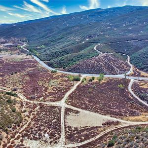
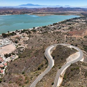
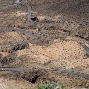
Rim of the World Scenic Byway
Scenic bywayCA
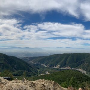

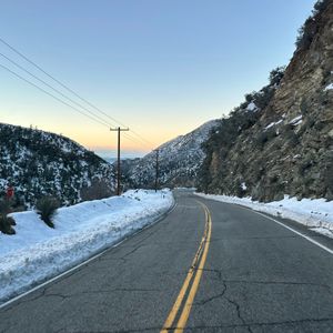
The original route was a Native American trading path connecting the valley floor to the mountain lakes. The modern road was built in the 1910s as a scenic highway for the first generation of Southern California motorists — people who'd just bought Model Ts and wanted to see what was up there. The stretch from Crestline to Running Springs is the payoff: long sweepers along the ridgeline with the entire San Bernardino Valley spread below like a map. Best driven at dawn, windows down, before the weekend lake traffic arrives.
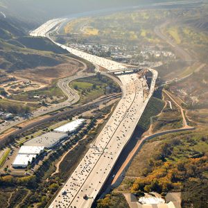
Arroyo Seco Historic Parkway
Scenic bywayCA
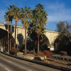
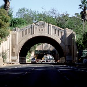
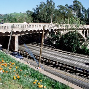
Opened December 30, 1940 — the first freeway in the American West, and still the most graceful. The alignment follows the Arroyo Seco, the seasonal creek that the Tongva people called home for centuries and that later gave Pasadena its identity as a garden city. The engineers who designed it treated the road as landscape architecture: sycamore-lined medians, gentle curves that follow the natural contour of the arroyo, elegant Art Deco bridges at Avenue 26 and York Boulevard. It was built for 45 mph and it still feels perfect at that speed — a reminder that freeways were once imagined as beautiful things. The stretch through South Pasadena is the finest piece of freeway engineering in the country, and the neighborhood fought for decades to protect it from widening. They were right to.
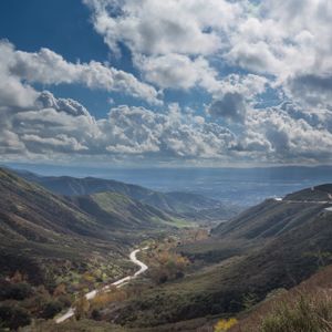
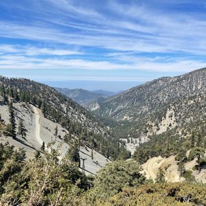
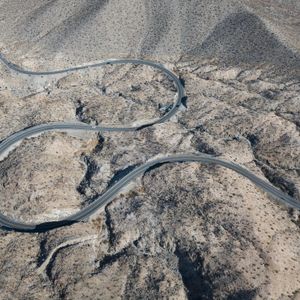
Angeles Crest Scenic Byway
Scenic bywayCA
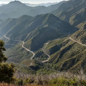
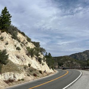
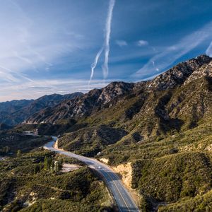
Built between 1929 and 1956 by crews who hand-cut switchbacks into the San Gabriel granite with dynamite and mule teams. Sixty miles from La Cañada Flintridge to Wrightwood, climbing from chaparral to alpine forest, with views that stretch from Catalina to the Mojave on a clear day. The Saturday morning run has been a SoCal ritual for decades — Porsche clubs, vintage British car groups, solo drivers who just need the mountains. The corners above Newcomb's Ranch are genuinely world-class. This is the road that made Los Angeles a car culture.
Angeles North
Scenic driveCA
A loop through the Sierra Pelona foothills that most Angelenos have never heard of. Lake Hughes climbs through oak savanna past a lake the Spanish said held a monster. San Francisquito passes the ruins of Mulholland's failed dam. Bouquet Canyon winds south past its reservoir through cottonwoods and live oaks. Four roads, zero traffic, pure SoCal backcountry.
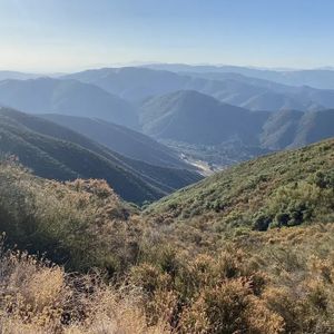
Angeles East
Scenic driveCA
Route 39 climbs north from Azusa into San Gabriel Canyon — a narrow river gorge that gets wilder with every mile until the road dead-ends at Crystal Lake near Windy Gap. From there the route backtracks and picks up forest service roads east toward Mt. Baldy, crossing ridgelines above 6,000 feet with views that stretch from desert to ocean. At 108 miles the it covers serious elevation change through some of the most rugged terrain in the San Gabriels.
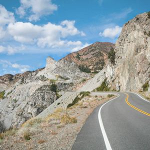
Route 74
Scenic bywayCA
Route 74 is the single greatest coast-to-desert road in America. One route number carries you 100 miles from San Juan Capistrano's marine layer over two mountain ranges to Palm Desert's 105-degree heat. The Ortega Highway section through the Santa Anas is some of the most technical canyon driving in Southern California. The descent off the San Jacintos drops through five climate zones in 25 miles — pines to palms — landing in the closed desert basin of the Salton Sea watershed. You cross land the Acjachemen and Cahuilla walked for millennia, on a two-lane road with almost nobody on it.
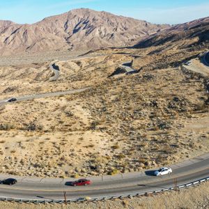
Palms to Pines Scenic Byway
Scenic bywayCA
Start in Palm Desert at 400 feet in full desert heat and climb through five distinct ecological zones — Sonoran desert, chaparral, oak woodland, transitional forest, mountain pine — arriving at Idyllwild at 6,000 feet in air that smells like Christmas. The Cahuilla people walked this route for thousands of years between their winter and summer camps. In a car, the switchbacks through the Santa Rosa Mountains are as rewarding as anything in the Dolomites, and considerably less crowded.
Riverside Freeway
Scenic bywayCA
The 91 through Santa Ana Canyon is the freeway nobody thinks of as a driving road — until they catch it empty on an early Sunday morning. The route cuts through a river gorge in the Santa Ana Mountains that served as a passage between the coast and the inland valleys long before the freeway existed. Native walnut groves still line the hillsides, and the canyon walls look the same as they did when early stage routes connected Anaheim to Riverside in the 1860s.